
Sidewalk Robots at Work Inside the Last Mile
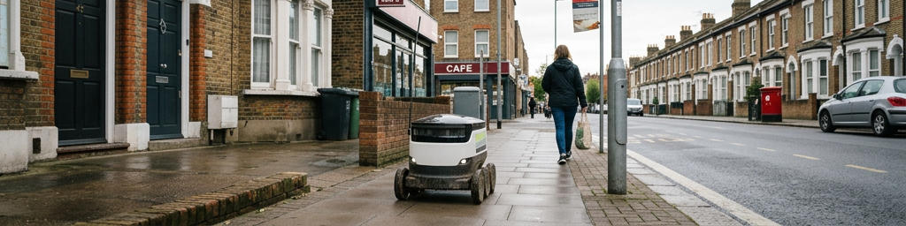
Small wheeled machines are starting to share pavements with pedestrians, quietly carrying groceries, take‑away meals and parcels through busy neighbourhoods and university campuses. Packed with cameras, lidar and on‑board computing, they continuously scan their surroundings, choose safe paths and adjust to changing street conditions in real time.
This story is part of Esgamesol's practical reading library across everyday topics.
What these small couriers actually do on pavements
Short hops between nearby hubs and doorsteps
These machines live at the very end of the delivery chain. Vans still handle longer trips from larger depots, but compact ground units cover the final stretch from a local store, dark kitchen, or micro‑hub to a doorstep or pickup point. They typically look like low, box‑shaped carts rolling at walking speed, with a locked storage compartment on top and batteries, motors, and control electronics beneath. Staff load one or several orders, seal the lid, and hand off the job in a digital dispatch system. The unit then rolls out to the pavement, follows a planned route, and waits at a designated spot until the recipient unlocks the lid using a code or app. The movement pattern is more shuttle‑like than a long journey: many short, repeated trips in a compact service area.
Where they fit among vans, bikes and people
Rather than replacing all other delivery options, these devices usually slot into a mixed network. They tend to focus on dense zones where many customers are within a short walking radius of a store or micro‑hub, and where curb space for large vehicles is scarce. Quiet, late‑evening grocery runs, repetitive food deliveries around campuses, or frequent small parcels in tightly packed neighbourhoods are typical use cases. Human couriers and riders still handle heavy or bulky items, complicated buildings, long distances and time‑critical jobs, while machines pick up low‑urgency, highly repeatable work. Over time, trip data about delays, walking speeds and waiting times helps operators decide which orders are best suited to robotic service and which should stay with people.
Practical limits in everyday streets
Despite impressive automation, there are clear boundaries. Stairs, broken slabs, steep kerbs, narrow doorways and deep puddles can all stop a run. Many services rely on recipients stepping outside to meet the unit at the curb or a lobby, making the “very last metres” a shared responsibility. Load capacity is modest, so large grocery baskets, furniture, or multi‑box office deliveries still need a person. Suburban sprawl and remote areas with long gaps between addresses remain difficult territory, where a single van often makes more sense than several small devices. In practice, the sweet spot tends to be walkable districts with reasonably continuous pavements, predictable crossings, and lots of short‑range demand.
How small machines read complex pavements
Seeing the path: cameras, depth and close‑range sensing
To move safely among people, each unit carries a bundle of sensing tools. Cameras capture rich visual detail such as kerb edges, bollards, signs, and pedestrians. Depth‑sensing systems — lidar, stereo vision or structured light — measure distance to objects and track how they move across time. Short‑range sensors, including ultrasound, infrared or simple bump switches, protect against close‑in hazards and act as a last safety net. These streams of raw data are processed on board into a live picture of the surrounding space. The system separates flat, rollable surfaces from obstacles, spots sudden changes such as cones or bins, and estimates how much room is available to pass.
Knowing “where exactly here” is
Pavement travel needs tighter position accuracy than most car sat‑navs can provide. Satellite signals often bounce around tall buildings or trees, so units combine them with wheel odometry, inertial measurements and visual landmarks. This fusion process, often called localisation, helps the device pin down not just its position on a high‑detail map, but also its heading and speed. Special maps focus on pedestrian details: pavement widths, ramp locations, kerb heights, slopes, legal access zones and preferred crossing points. Each run adds more knowledge, gradually enriching the map with preferred shortcuts, tricky corners and spots that are regularly blocked.
Making decisions in a shared social space
Sidewalks are social environments, not just technical ones. Algorithms predict short‑term paths for nearby people, pets, bikes and pushchairs so the device can yield early, slow gently, or take a wide line around groups. Lights, indicators or soft chimes signal intent at crossings or when starting to move, giving bystanders subtle cues about what will happen next. When the system encounters something it does not understand — a confusing sign, a flooded path, a maze of barriers — it can pause and call a remote human operator for guidance. In bad weather or low light, behaviour becomes more conservative: slower speeds, larger gaps, and greater willingness to stop or reroute.
Picking routes and managing a small urban fleet
From order list to pavement itinerary
Before any wheel turns, a central platform gathers orders, knows where each unit is, tracks battery levels and understands the local walking network. It groups nearby destinations into efficient tours, decides which device should handle which cluster, and chooses a stop sequence. Because these units move slowly compared with road traffic, clustering orders in compact zones matters more than shaving a handful of metres from individual routes. Time windows, local rules and hub capacity shape these choices: one device might be dedicated to quiet residential blocks during the evening, another to short runs between a grocery outlet and nearby apartment complexes during the day.
Balancing batteries, distance and disruption
Energy limits add an extra constraint. Every slope, rough patch, stop‑start interaction and extra kilogram of load changes how far a device can reasonably travel. Planning tools estimate consumption for a proposed route and keep a reserve so the unit can always get back to a base or charging station. Busy operations might rotate units through charging cycles, swap batteries between runs, or deliberately route journeys past charging points. At the same time, planners look beyond pure distance: a slightly longer but smoother, less crowded route may reduce delays and energy use compared with a technically shorter but chaotic corridor filled with obstacles and frequent stops.
Choosing practical operating zones
Not every street grid suits these small ground couriers equally well. Narrow pavements, frequent steps, heavy foot traffic and constant loading activity can make some blocks poor candidates, while nearby side streets might be ideal. Operators often sketch out “friendly corridors” where conditions, rules and public acceptance align, then gradually expand as experience grows. In some settings, these corridors link micro‑hubs with building entrances or shared pickup points, forming a lattice that larger vans feed from outside. Over time, patterns in delay hotspots, blocked paths and smooth flows feed back into planning, fine‑tuning where units are sent and when.
Example: matching use cases to deployment choices
The table below illustrates how different service goals push fleet managers toward different operating patterns and street types.
| Service focus | Typical area and street pattern | How units are usually used |
|---|---|---|
| Quiet residential groceries | Compact neighbourhood blocks, moderate pavements | Repeated short loops from a nearby hub, flexible arrival times |
| Campus or business‑park meals | Internal paths, plazas, limited external road crossings | High‑frequency shuttles between kitchens and known pickup spots |
| Mixed‑use urban parcels | Dense blocks, restricted curb space, varied pavements | Combination of locker drops, lobby stops and doorstep meet‑ups |
| Evening or off‑peak deliveries | Areas with fewer pedestrians but active local demand | Scheduled rounds during calmer hours to minimise disturbance |
These patterns are not strict rules, but they show how service design, street layout and technology constraints interact when deciding where and how to use small pavement‑based fleets.
Hardware on small wheels: design for real pavements
Body, wheels and stability choices
The hardware resembles a compact, low‑centered trolley. Most models use multiple rubber‑tyred wheels, often with suspension to handle cracks and shallow kerbs. Wheel size, spacing and drive layout all influence how well the device climbs ramps, turns in tight spaces and recovers from bumps or small holes. The cargo bay usually sits above the drive system, kept as low as possible to maintain stability on slopes or when one wheel drops into a dip. Rounded corners and smooth shells reduce snagging on bags or clothing when passing close to people.
Power, motion and safety layers
Rechargeable batteries supply electric motors through a motion controller that translates planned paths into gentle accelerations and smooth braking. Limiting top speed and abrupt moves helps protect both pedestrians and the goods inside, especially drinks or delicate items. Multiple safety layers sit on top of navigation: conservative collision‑avoidance zones, emergency stop buttons, and automatic halts when sensors detect something too close or data becomes unreliable. Regular maintenance checks wheels, braking performance, suspension, lights and audible alerts, because small physical faults can have visible consequences on narrow, shared paths.
Comparing small pavement units with other last‑segment options
The following table contrasts typical strengths and weaknesses of compact ground robots with two common alternatives in the final stretch of delivery.
| Option | Typical strengths | Common trade‑offs or limits |
|---|---|---|
| Pavement‑based robots | Low noise, small footprint, consistent pace, rich data feedback | Limited load, sensitive to poor pavements and steps |
| Human walker or rider | Flexible access, good judgment in unusual situations | Labour‑intensive, tiring on repetitive short hops |
| Small van or car | Larger loads, weather‑resistant, wide reach | Needs parking space, can add to congestion and curb conflicts |
Operators often mix these options, assigning each to the tasks and streets where its particular balance of strengths and trade‑offs fits best.
Where small rolling couriers might go next
Integration with neighbourhood logistics
As experience grows, more fine‑grained patterns appear. Micro‑depots, pickup lockers and shared lobby points make routes shorter and easier to repeat. Data from everyday runs highlights where pavements could benefit from new ramps, resurfacing or clearer markings, offering useful input to planners who manage walking networks. Businesses may adjust store layouts or opening hours to line up with quiet, low‑impact restocking runs, spreading goods movement away from already busy times on the road.
Living alongside residents and local rules
Growth depends heavily on comfort and trust. Trials in limited areas, open feedback channels and visible responsiveness to complaints help devices feel like considerate guests rather than intrusive machines. Speed caps, polite passing behaviour, clear labelling and simple ways to pause or report a unit all contribute. Instead of aiming to replace human presence, these systems work best when framed as another tool in a wider kit: a way to handle certain predictable trips gently and reliably, while people focus on tasks that need judgment, strength, conversation or flexibility. In that role, small wheels can become a relatively quiet, almost background part of everyday street life.
Q&A
-
How are Urban Navigation Systems changing real-time decision-making in dense city environments?
Urban Navigation Systems now fuse GPS, 3D maps, live traffic, curb space and curb-use rules, enabling dynamic rerouting for vehicles, bikes, and robots while respecting local regulations and micro-zones like school streets or pedestrianized blocks. -
What role does Last Mile Logistics Tech play in cutting delivery costs and emissions?
Last Mile Logistics Tech clusters orders, optimizes routes, picks suitable modes (van, cargo bike, robot), and schedules off-peak windows, reducing failed deliveries, congestion, and idling, which directly lowers fuel use, CO₂, and labor costs. -
Why is Sensor-Guided Mobility essential for safe operations on sidewalks and shared spaces?
Sensor-Guided Mobility uses cameras, lidar, radar, and ultrasonic sensors plus edge AI to detect pedestrians, pets, curbs, and obstacles, allowing robots and small vehicles to yield, slow, or reroute in real time, improving safety and compliance. -
What are the key design trade-offs in Sidewalk Robotics Design for urban deployments?
Sidewalk Robotics Design must balance size, speed, and payload with maneuverability, accessibility for users, weather resistance, and social acceptance, while meeting local rules on weight, operating hours, and right-of-way on narrow sidewalks. -
How does Automated Route Planning support Smart Delivery Operations at scale?
Automated Route Planning integrates orders, traffic, fleet capacity, service-time rules, and live sensor data to generate and update routes automatically, underpinning Smart Delivery Operations that can coordinate mixed fleets across entire city districts.